Wednesday, December 31, 2014

CFS Carp Almonte Detachment

Waymark Code: WMN65Z

N 45° 15.71 W 076° 9.138

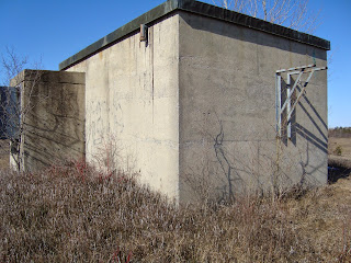
In 1962 at the height of the Cold War, Canadian Forces Station Carp became operational. Remote radio receiving facilities were created to support CFS Carp. One of these facilities was an antennae yard established here, east of Almonte. All of CFS Carp operations, including the Almonte detachment were abandoned by 1994. The Nature Conservancy of Canada soon took over maintenance of the land for environmental protection. Eventually, the land would be included in the Ontario Parks system as Burnt Lands Provincial Park.

This abandoned concrete building (measuring 25.8 metres square) from the Cold War period has survived all the changes. The building is near the centre of the closed military facility.

According to the Ontario Parks Burnt Lands Interim Management Statement (2001), communications towers erected in 1960 have since been removed from the property (concrete base plates remain). A bunker, previously used to contain a backup generator and batteries for the communications towers, remains on the property.

Tuesday, December 30, 2014

M&O Railway: milepost 81

The M&O subdivision of the Canadian Pacific Railway began as the Montreal & Ottawa Railway in 1898. By the time the rails were removed in 1986, the railbed was being used by VIA Rail passenger service. The property still belongs to VIA. Today, that portion of the former railbed in Prescott and Russell county is known as the Prescott and Russell Recreational Trail. That portion of the trail which resides in the city of Ottawa, where these waymarks can be visited, has been known as the Prescott Russell Trail Link.

These two culverts date from a period with many building projects along this railway. Most of the culverts on the M&O date from this period. Interestingly, the 1914 culvert is in better shape than the 1924 culvert. The location for the 1914 culvert would have been known by railroaders as milepost 81.7, the 1924 culvert as milepost 82.2. Therefore, these culverts are respectively 81.7 and 82.2 miles from the M&O connection with the Vaudreuil subdivision at the junction in Dorion near Montreal.

When I return to these culverts in better light, I will obtain better photographs for waymarking in the Dated Architectural Structures Multifarious category.

N 45° 24.96 W 075° 34.359
N 45° 24.878 W 075° 34.893

Monday, December 29, 2014

Canadian benchmark: 6530316

Waymark Code: WMN5JX

Station Report
Site Identification
Name Province NTS map sheet Unique Number Provincial Identifier NCC 316 Ontario 031G05 6530316 019680316
Horizontal Data
Values should be checked with the provincial agency before use.
Geographic
Latitude Longitude Horizontal Datum Order Method Published Year 45° 24' 16.7079" 75° 31' 37.5901" NAD83 Consult agency (unique condition) Multiple methods 90-01-01 UTM Zone Easting (metres) Northing (metres) Scale 18 458749.259 5028037.614 .99962 Vertical Data Vertical Datum Elevation (m) Order Method Gravity (mGal) Published Year CGVD2013 New 76.317 First order Differential 980616.7 ± .8 2013 CGVD28 76.626 First order Differential 980616.7 ± .8 1967
Station Marker
Marker Type Inspected in Established by Status Comments Brass/bronze tablet or cap 1965 National capital commission Good None
Location Ottawa For descriptions contact survey section, n.c.c.

The station report above is taken from the Canadian Spatial Reference System (CSRS) on-line database maintained by Natural Resources Canada.

When it comes to waymarking, I would rather be seeking benchmarks than any other objects. Snow cover was minimal. I was headed out on Dolman Ridge for one more geocache. I put the aforementioned co-ordinates in my GPSr.

I was surprised to encounter only the post, especially because the station report describes a tablet or cap. The published co-ordinates were a perfect match. There was no snow cover. Perhaps fifty years of grass, moss and soil have covered over the disk.

The round trip from the open end of Dolman Ridge Road was 4 kilometres.


Sunday, December 28, 2014

Dead vehicle: MG MGA, 1958

Waymark Code: WMQTQ8

N 45° 18.892 W 075° 51.6

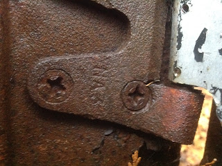
This car lies in National Capital Commission wilderness once known as Nepean township, concession 5, lot 6. The British Racing Green paint colour should have steered me in the right direction from the start. However, it was not until I spotted the MOWOG foundry stamp that I was certain of the manufacturer. MOWOG is the previously used acronym for MG: Morris-Wolesely Garages.

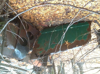
This waymark was actually rejected by reviewers in the Dead Vehicles waymarking group due to upside down photographs accompanying my description. Photography with my iPad often results in upside down images when these images are viewed on other personal computers. Therefore, I am careful to edit the photographs before I publish. However, if the category reviewer examined the corrected photographs on an Apple device, the images may have been reinverted. See below. The reviewer should have known of this issue. Despite enjoying this category, I will no longer submit official waymarks to the category.

Friday, December 26, 2014

Dead vehicle: Dodge 6, 1932

Waymark Code: WMQTQ0

N 45° 24.12 W 075° 32.26

I enjoy the hunt for the dead vehicles and then the research to identify the vehicles. In many cases, it's difficult to imagine how the car got itself stranded in the middle of the forest. In this case, it's easier to understand. There was once an east-west backwoods road along the southern edge of Dolman Ridge, near to and along the line between concessions 4 and 5. At some point, this car was abandoned and tossed off the ridge.

Gloucester township, Ottawa front, concession 5, lot 9

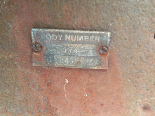
The body stamp identifies the model as DL, body number 174. That information identifies the Dodge car.

Monday, December 22, 2014

Why

Waymark Code: WMN5DE

On the groundspeak forum, there has been too much mention of the demise of waymarking. Therefore, I thought it important to have an additional outlet for those interesting places that we visit as waymarkers. My first stop represents a brand new, not-yet-published waymarking category: Continental Reformed and Congregational Church Sites.

N 45° 23.255 W 075° 36.054

I visited the Calvary Christian Reformed Church at 3782 Russell Road, Ottawa, Ontario, Canada K1G 3N2 or telephone 613-737-4063. This church is affiliated with the Christian Reformed Church in North America.

According to the web site, worship services are Sundays at 10h00 with a more informal gathering at 18h30, with children’s worship, Sunday school and nursery available during the morning service. During the summer months we have a service only at 10h00 with children's worship for 3 to 6 year olds and nursery available.

The date stone at the church is from 1968.

The church is on the south side of Russell Road, east of Walkley.

http://www.calvarycrc.ca/index.php?option=com_frontpage&Itemid=26